
Conservation and Land Management
Australia's landscapes are under pressure. Climate change is shifting rainfall patterns, lengthening fire seasons, and pushing species beyond their historical ranges. Invasive species, habitat fragmentation, and changing land use continue to erode biodiversity at a pace that demands a coordinated response. But within these challenges lies real opportunity — to rethink how we manage land, to invest in restoration at scale and to build resilience into the landscapes that communities, industries and ecosystems all depend on. At Future Ecosystems, we work with landholders, Traditional Owners, government agencies and communities to turn that opportunity into action — developing strategies that are grounded in science, responsive to change and built for the long term.

Regional Natural Resource Management Planning
Food Forest Design
In a world where environmental spending in Australia by government is declining year on year and the challenges are getting greater, effective natural resource management depends on plans being highly strategic, spatially explicit and carefully targeted. We support regional NRM bodies, local governments, and land managers in developing integrated plans that align conservation priorities with on-ground capacity and funding cycles.
Our approach draws on current best practice in landscape-scale planning, incorporating both workshop-based planning and data-driven approaches to define conservation values and conservation significance, current condition, threat assessment, situation analysis and strategy development to produce strategies that are both high impact and achievable. We understand the complexity of working across tenures and with diverse communities of interest, and we bring that experience to every regional planning process we support.
Spatial Prioritisation
When resources are finite and the landscape is complex, knowing where to act first makes all the difference. We use spatial analysis and systematic conservation planning tools to help organisations identify where investment will deliver the greatest ecological return.
Whether you're allocating restoration funding across a catchment, designing a monitoring program, or determining which areas warrant immediate protection, we can help you make decisions that are defensible, transparent, and aligned with your conservation objectives. Spatial prioritisation integrates spatial data about values, threats, constraints and opportunities to prioritise among potentially competing projects. Future Ecosystems has developed an approach that combines workshop-based planning together with cutting edge conservation prioritisation software to develop sophisticated prioritisation outputs that are grounded in practical, on-ground knowledge.
Examples of software tools used for this process include:
-
The Connectivity Analysis Toolkit and Circuitscape are great for mapping wildlife corridors
-
Zonation is good for mapping biodiversity hotspots and developing a Conservation Significance layer
-
Marxan is good for zoning areas into potentially competing land uses
-
The National Carbon Accounting Toolbox is useful for estimating carbon sequestration from changes in land management.
Examples of recent projects include:
-
prioritising areas for grazing land management in the erosion-sensitive Great Barrier Reef catchments of northern Queensland
-
mapping High Conservation Values within plantation forestry estates
-
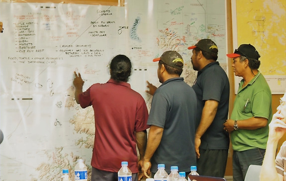
working with indigenous groups in the Kimberley region of Western Australia to integrate the mapping of biological and cultural values and zone areas into protection and sustainable use
-
prioritising wildlife corridors to enhance landscape connectivity in South Australia and Victoria


Ecological Surveys
-
Vegetation Assessment
We assess plant communities against regional benchmarks and ecological condition frameworks, identifying floristic composition, structure, weed pressure, and conservation values. Our reports are suitable for environmental impact assessment, offset calculations, and management planning.
-
Flora and Fauna Surveys
We design and conduct targeted flora and fauna surveys that meet regulatory requirements and answer on-ground management questions. From threatened species assessments to broad biodiversity inventories, we tailor our methods to the landscape and the purpose.
-
Bird Surveys
Birds are reliable indicators of ecosystem health and are often central to biodiversity assessments and monitoring programs. We use point counts, transects, and acoustic monitoring to characterise bird communities and track change over time. We have extensive survey experience across a range of ecosystems, from coastal heathlands to arid woodlands.
All survey work is conducted by qualified ecologists, with reports that are rigorous, clearly presented, and fit for purpose.
Ecological Restoration and Revegetation Planning
Effective ecological restoration requires an understanding of the ecological context, choosing the right species and an understanding of future climate change impacts to set up conditions for long-term success.
We develop restoration and revegetation plans that are ecologically informed and practically grounded. Our work spans everything from small-scale riparian plantings to large landscape restoration programs.
Plans typically include:
-
Site condition assessment and reference ecosystem identification
-
Seed provenance guidance and species selection
-
Site preparation and weed management recommendations
-
Staged implementation schedules
-
Performance monitoring frameworks
We work closely with land managers throughout the process, building capacity and providing practical guidance so that restoration efforts endure well beyond our direct involvement.


Climate Change Vulnerability Assessment and Adaptation Planning
Understanding how ecosystems will respond to a changing climate is no longer a niche research question — it's a core requirement of responsible land management. We help organisations assess the vulnerability of their landscapes, species, and ecological communities to current and projected climate change, and develop adaptation strategies that are realistic, evidence-based and fit for purpose.
Our vulnerability assessments are built on established scientific frameworks — including exposure, sensitivity, and adaptive capacity approaches — and draw on a rich suite of spatial datasets and modelling tools. We integrate projected changes in temperature and rainfall, ecological condition trajectories, and modelled shifts in vegetation distribution to build a nuanced picture of where and how climate change will reshape the landscape. Where coastal and estuarine systems are involved, we incorporate sea level rise projections and storm surge modelling to assess inundation risk and the long-term viability of habitats under a range of emissions scenarios.
Species distribution change modelling can help us to identify which species are likely to contract, expand, or shift their ranges, and where refugial habitats — areas buffered from the worst climate impacts — may play a critical role in maintaining populations through periods of rapid change. Identifying and protecting refugia is increasingly central to conservation planning, and we bring targeted spatial analysis to this task.
These layers of information are integrated into a coherent vulnerability assessment that identifies priority areas for intervention, highlights where existing management approaches may no longer be sufficient, and provides a foundation for informed adaptation planning.
Adaptation Planning
Vulnerability assessment is only useful if it leads to action. We work with clients to translate assessment findings into practical adaptation plans — strategies that adjust management approaches, protect refugial areas, enhance landscape connectivity and build long-term ecological resilience. In revegetation and restoration contexts, this includes the application of climate-adjusted seed provenance strategies, selecting seed sources from populations that reflect projected future climates rather than current conditions, to ensure that plantings are viable not just today but across the decades ahead.
Ready to talk about your project? We welcome enquiries from landholders, land managers, government agencies, and community groups. Every landscape is different, and we take the time to understand yours before recommending an approach.